Class 9 Geography Drainage Question Answer NCERT Solution in Hindi. NCERT Class 9 Geography Question Answer and Important Question Answer, Textual Question answer also Available for Various Board Students like HBSE, CBSE, UP board, Mp Board, RBSE and some other State Boards.
- Also Read:- Class 9 Geography NCERT Solution
- Also Read :- HBSE Class 9 All Subject Important Questions ( Latest )
- Also Read :- CBSE Class 9 All Subject Important Questions ( Latest )
NCERT Solution for Class 9 Geography Chapter 3 Drainage textual Question Answer.
Drainage Class 9 Geography Question Answer
Q1. Choose the right answer from the four alternatives given below.
(i) In which of the following states is the Wular lake located?
(a) Rajasthan
(b) Uttar Pradesh
(c) Punjab
(d) Jammu and Kashmir
Ans. (d) Jammu and Kashmir
(ii) The river Narmada has its source at
(a) Satpura
(b) Brahmagiri
(c) Amarkantak
(d) Slopes of the Western Ghats
Ans. (c) Amarkantak
(iii) Which one of the following lakes is a salt water lake?
(a) Sambhar
(b) Dal
(c) Wular
(d) Gobind Sagar
Ans. (a) Sambhar
(iv) Which one of the following is the longest river of the Peninsular India?
(a) Narmada
(b) Krishna
(c) Godavari
(d) Mahanadi
Ans. (c) Godavari
(v) Which one amongst the following rivers flows through a rift valley?
(a) Mahanadi
(b) Tungabhadra
(c) Krishna
(d) Tapi
Ans. (d) Tapi
Q2. Answer the following questions briefly.
(i) What is meant by a water divide? Give an example.
Ans. Any elevated area, such as mountain or an upland, separates two drainage basins. Such an upland is known as water divide. eg. Ambala is on a water divide of the Indus and the Ganga river systems.
(ii) Which is the largest river basin in India?
Ans. The Ganga Basin is the largest river basin in India.
(iii) Where do the rivers Indus and Ganga have their origin?
Ans. The river Indus rises in Tibet, near Lake Mansarowar. The river Ganga originates from Gangotri Glacier, Uttarakhand.
(iv) Name the two headstreams of the Ganga. Where do they meet to form the Ganga?
Ans. There are two headstreams of the Ganga are as :
1. Bhagirathi originates from Gangotri Glacier
2. Alaknanda originates from Satopanth Glacier
Both the rivers meet at Devaprayag in Uttaranchal.
(v) Why does the Brahmaputra in its Tibetan part have less silt, despite a longer course?
Ans. The Brahmaputra in its Tibetan part have less silt, despite a longer course because Tibet is a cold and dry area.
(vi) Which two Peninsular rivers flow through trough?
Ans. Narmada and Tapi rivers are those peninsular rivers which flow through trough.
(vii) State some economic benefits of rivers and lakes.
Ans. Some economic benefits of rivers and lakes are as :
1. Provide water for irrigation.
2. Provide sand, silt for industrial use.
3. Recreation, tourist promotion and fishing are also being developed along waterfronts.
4. Rivers provide means of transport and inland waterways.
Q3. Below are given names of a few lakes of India. Group them under two categories – natural and created by human beings.
(a) Wular
(b) Dal
(c) Nainital
(d) Bhimtal
(e) Gobind Sagar
(f) Loktak
(g) Barapani
(h) Chilika
(i) Sambhar
(j) Rana Pratap Sagar
(k) Nizam Sagar
(l) Pulicat
(m) Nagarjuna Sagar
(n) Hirakund
Ans.
| Natural lakes | Man-made lakes |
| (a) Wular (b) Dal (c) Nainital (d) Bhimtal (f) Loktak (g) Barapani (h) Chilika (i) Sambhar (l) Pulicat | (e) Gobind Sagar, (j) Rana Pratap Sagar, (k) Nizam Sagar, (m) Nagarjuna Sagar, (n) Hirakund |
Q4. Discuss the significant difference between the Himalayan and the Peninsular rivers.
Ans.
| Himalayan Rivers | Peninsular Rivers |
| 1. Most of the Himalayan rivers are perennial. It means that they have water throughout the year. | 1. Most of Peninsular river depend upon rain so they are seasonal. |
| 2. longer and deeper courses | 2. These rivers have shorter and shallower courses as compared to their Himalayan counterparts. |
| 3. They perform intensive agriculture and carry huge amount of silt. | 3.These rivers don’t carry silt at large amount. |
| 4. Examples. The Indus, The Ganga and the Brahmaputra are major Himalayan river. | 4. Examples. The Mahanadi, The Godavari, The Krishna, The Kaveri, The Narmada and the Tapi are major Peninsular rivers. |
Q5. Compare the east flowing and the west flowing rivers of the Peninsular plateau.
Ans.
| East flowing rivers | West Flowing rivers |
| 1. Major east flowing rivers are – Godavari, Krishna, and Kaveri. | 1. Major west flowing rivers are Narmada and Tapi. |
| 2. These rivers form deltas. | 2. These rivers don’t form deltas. |
| 3. These rivers fall into Bay of Bengal. | 3. These river fall into Arabian Sea. |
Q6. Why are rivers important for the country’s economy?
Ans. Rivers are important for Economy of the country for following reasons are as :
1. Provide water for irrigation.
2. Provide sand, silt for industrial use.
3. Recreation, tourist promotion and fishing are also being developed along waterfronts.
4. Rivers provide means of transport and inland waterways.
Map Skills
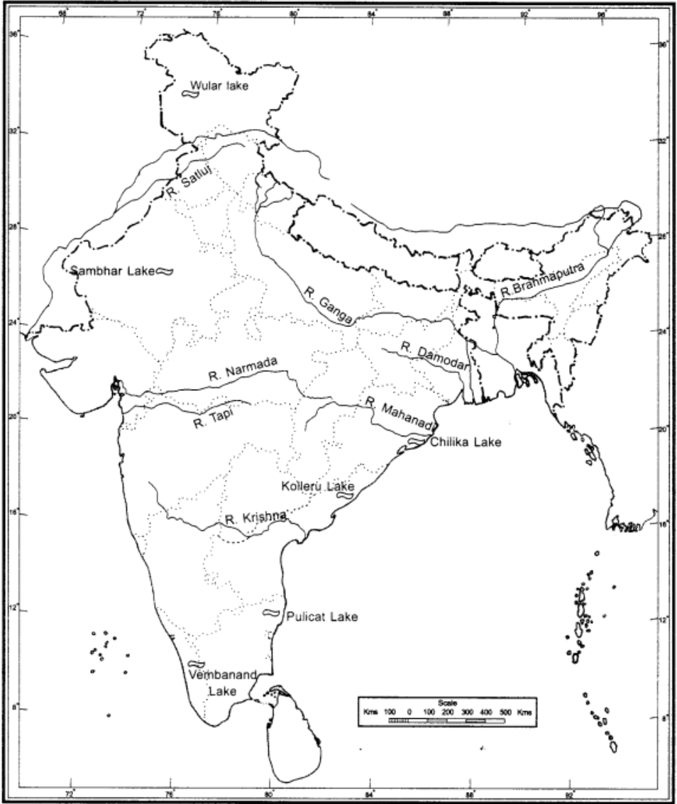
(i) On an outline map of India mark and label the following rivers: Ganga, Satluj, Damodar, Krishna, Narmada, Tapi, Mahanadi, and Brahmaputra.
(ii) On an outline map of India mark and label the following lakes: Chilika, Sambhar, Wular, Pulicat, Kolleru.
Ans.
Project/Activity
Question:- Solve this crossword puzzle with the help of given clues.
1. Nagarjuna Sagar is a river valley project. Name the river?
Ans. Krishna river
2. The longest river of India.
Ans. Ganga river
3. The river which originates from a place known as Beas Kund.
Ans. Beas
4. The river which rises in the Betul district of MP and flows westwards.
Ans. Tapi river
5. The river which was known as the “Sorrow” of West Bengal.
Ans. Damodar
6. The river on which the reservoir for Indira Gandhi Canal has been built.
Ans. Sutlej
7. The river whose source lies near Rohtang Pass.
Ans. Beas
8. The longest river of Peninsular India?
Ans. Godavari river
9. A tributary of Indus originating from Himachal Pradesh.
Ans. Chenab river
10. The river flowing through fault, drains into the Arabian Sea.
Ans. Narmada river
11. A river of south India, which receives rainwater both in summer and winter.
Ans. Kaveri River
12. A river which flows through Ladakh, Gilgit and Pakistan.
Ans. The Indus River
13. An important river of the Indian desert.
Ans. Luni river
14. The river which joins Chenab in Pakistan.
Ans. Jhelum river
15. A river which rises at Yamunotri glacier.
Ans. Yamuna river