NCERT Class 11 Geography Chapter 2 Structure and Physiography Notes Solution For School Students of Class 11th. We also Provides Notes and Important Questions for Class 11 Geography. NCERT Class 11th Geography book is applied in mostly boards like CBSE, HBSE, RBSE, Up Board, MP Board and also some other state boards.
Also Read:- Class 11 Geography India Physical Environment NCERT Solution
NCERT Class 11 Geography india physical environment Chapter 2 Structure and Physiography Notes for CBSE, HBSE and Other Boards Solution.
Structure and Physiography Class 11 Geography Notes
- Our Earth is approximately 460 million years old.
The Peninsular Block:-
- The Peninsular is formed essentially by a great complex of very ancient granites.
- Examples:- Karbi Analong and Meghalaya plateau in the northeast and Rajasthan in the west are also extensions of this block.
- In Rajasthan, the desert and other closest like features overlay this block.
The Himalayan and other Peninsular Mountains:-
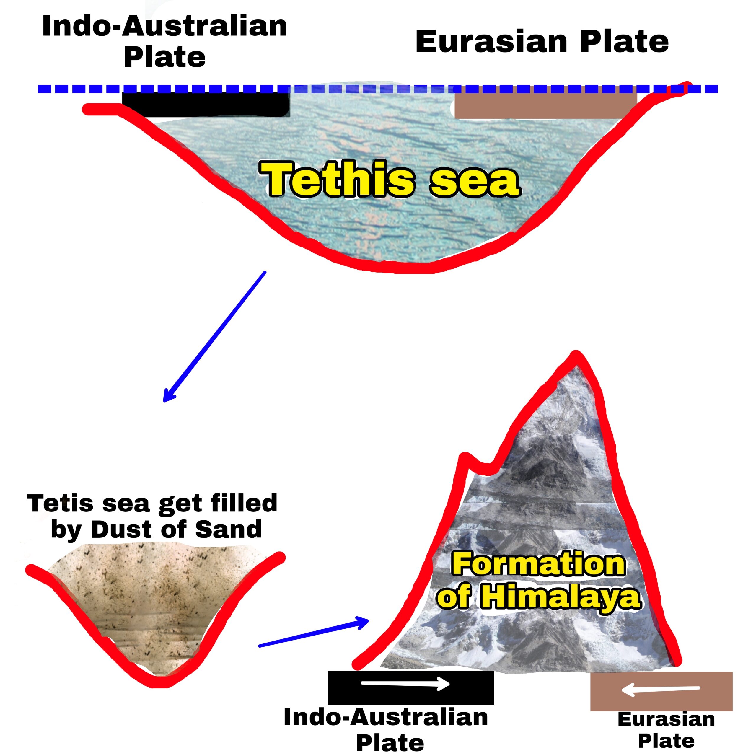
- Himalaya is young, weak and flexible.
- Plates still converging and height of Himalaya is increasing.
- Mountains are tectonic in origion and varied by fast flowing rivers.
- Various V shaped valleys, rapids, waterfalls etc. are indicative of this stage.
Indo-Ganga-Brahmaputra Plain:-
- Average depth of alluvial deposits in these plains ranges from 1000-2000m.
Physiography:– Physiology of an area is the outcome of structure, process and the stage of development.
- The land of India is characterized by great diversity in its physical features.
- Based on the variations, India can be divided into the following Physiographic divisions:-
- The North and North Eastern Mountains(Himalayas)
- The Northern Plain (formed by rivers)
- The Peninsular Plateau
- the Indian Desert
- The Coastal Plains
- The Islands
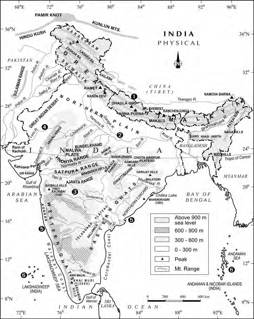
The North and North Eastern Mountains:-
- They consist of the Himalayas and the Northeastern hills.
- The Himalayas consist of a series of parallel mountain.
- The general orientation of these ranes is from northwest to the southeast direction in the northwestern part of India.
- The approximate length of Great Himalayan range, also known as the Central Axial Range, is 2500Km from east to west, and their width varies between 160-400Km from North to South.
- On the basis of relief, alignment of ranges and other features, the Himalayas can be divided into the following sub divisions.
Kashmir or Northwestern Himalayas:- Trans Himalaya
- It comprise of a series of ranges such as Ladakh, Zaskar etc.
- Important glaciers also found in this region such as Baltoro and Siachen.
- Kashmir Himalayas also famous for Karewas formation.
- Famous for cultivation of Saffron.
- Fresh water lakes (Dal Lake) and salt water lakes also fount there.
- This region consists of duns like Pathan Kot Dun.
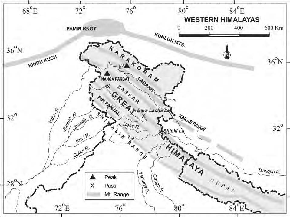
Himachal and Uttarakhand Himalayas :- Greater Himalayas
- This region lies approximately between the Ravi (in the west) and the Kali (in the east) rivers.
- Northwestern part of Himachal Himalayas is an extension of the Ladakh.
- Some of the important hil stations such as Shimla, Mussoorie were developed in this region.
- Two features of this region are Shiwalik and Dun formations.
- Some Duns located in this region are Dehradun, Kota dun etc.
- The famous “Valley of Flowers” is also situated in this region.
- This region is also known to have five famous Prayags.
- From Nanga Parvat to Namcha Barva also known as Tibetan Plateau.
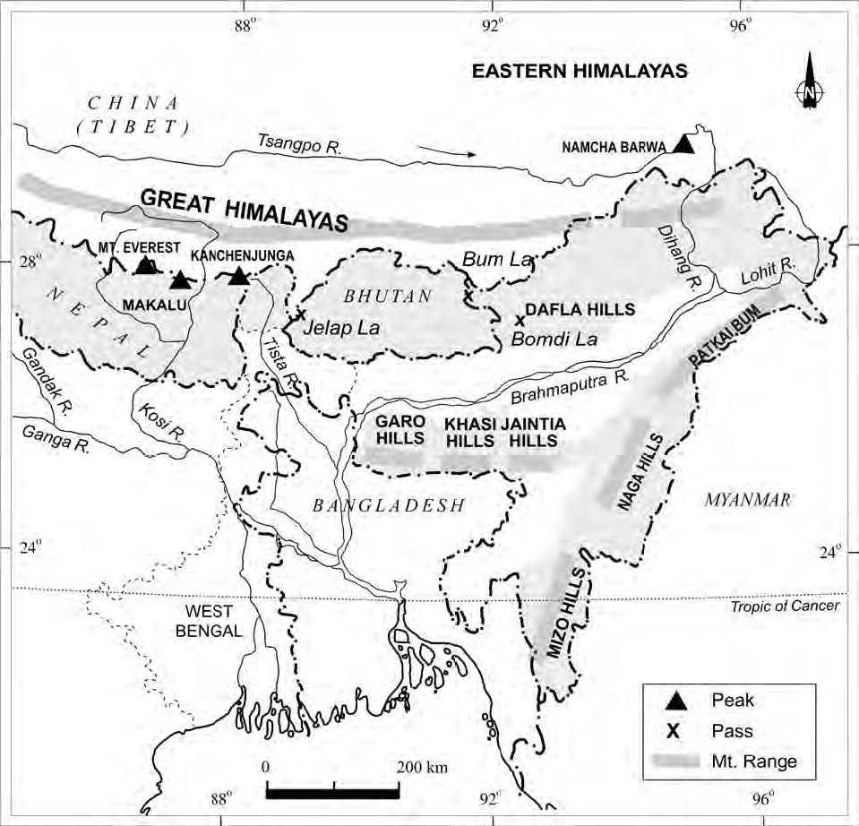
The Darjiling and Sikkim Himalayas:- Middle Himalayas
- They are flanked by Nepal Himalayas from west and Bhutan Himalayas from east.
- It is small.
- It is know for its fast flowing rivers such as Tista.
- Absence of Shiwalik formations.
- Sikkim and Darjiling Himalayas are also known for their scenic beauty.
The Arunachal Himalayas :- Shiwalik Range
- These extend from the east of the Bhutan Himalayas upto the Dipree pass in the east.
- General direction of the mountain range is from southwest to northeast.
- Important mountain peaks are Kangre and Namcha Barwa.
- Dissected by fast flowing rivers from the north to the south.
- Numerous ethnic tribal community inhabiting in these areas.
- Jhumming cultivation is pracitsed.
- Rich in biodiversity.
The Eastern Hills and Mountains:- Purvanchal (series of low hills)
- Having alignment from the north to south direction.
- They are know by different local names such as In North – Patkai Bum, Naga Hills, the Manipur Hills. In South – Mizo or Lushai Hills.
- Inhabited by tribal groups.
- Jhum cultivation is practised.
- Most of the ranges are separated from each other by small rivers.
The Northern Plains :-
- These are formed by the alluvial deposits brought by the rivers like the Indus, the Ganga and the Brahmaputra.
- These plains extend approximately 3,200 km from the east to the west .
- The average width of these plains varies between 150 to 300km.
- The maximum depth of alluvium deposits varies between 1000 to 2000 meter.
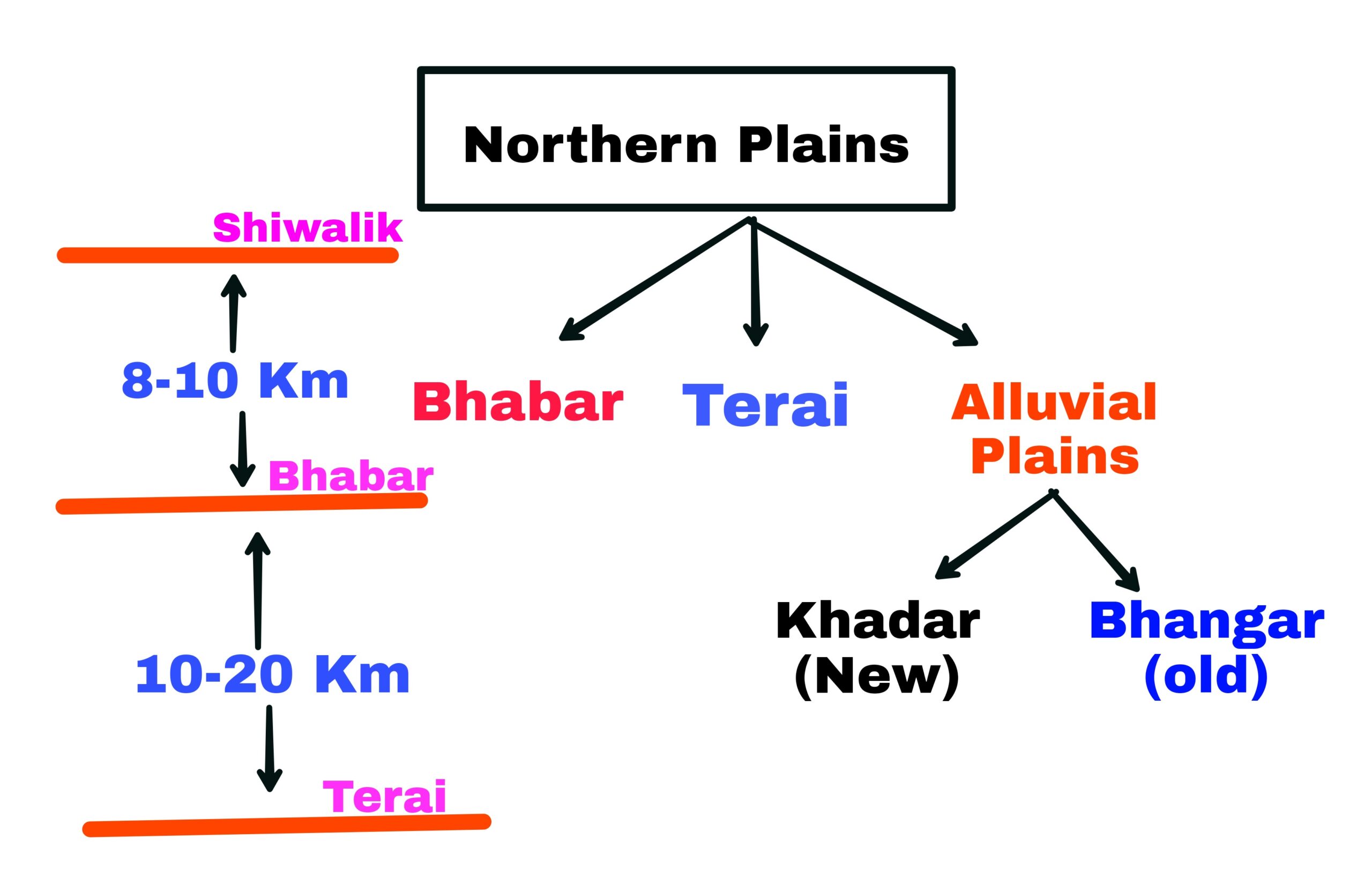
- Bhabar is narrow belt ranging between 8 to 10 kilometer parallel to the Shivalik.
- Terai is ranging between 10 to 20 kilometer parallel to the Bhabar.
- This has a luxurious growth of natural vegetation and houses a varies wildlife.
- The Brahmaputra plains are also known for their riverine islands and sand bars.
- These river valley plains have a fertile alluvial soil cover which supports a variety of crops like wheat, rice, sugarcane and jute.
- It supports a large population.
The Peninsular Plateau:
- It is the one of the oldest and most stable landmass of India.
- Rising from the height of 150m above the river plains upto an elevation of 600-900m is the irregular triangle known as the Peninsular Plateau.
- It is made up of a series of patland plateaus such as the Hazaribagh plateau, the Malwa plateau etc.
- General direction is from west to east.
- Some important physiographic features of this region are tors, black mountains, rift valleys etc.
- In the basis of the prominent relief features, The Peninsular plateau can be divided into three broad groups:-
- The Decan Plateau
- The Central Highlands
- The Northeastern Plateau
The Deccan Plateau :-
This is bordered by the western ghats, Eastern Ghats and Satpura, Maikal range in the north.
- Western Ghats are comparatively higher in elevation and more continuous than the Easter Ghats.
- Their average elevation is about 1500m with the height increasing from North to South.
- Anamudi is the highest peak of Peninsular plateau is located on Western Ghats.
- Most of the Peninsular rivers have their origin in the western Ghats.
- Eastern Ghats comprising the discontinuous and low hills.
- Some important ranges include the Javadi Hills, the Mahendragiri hills etc.
- The western and Eastern Ghats meet each other at the Nilgiri Hills.
The Central Highlands:-
- They are bounded to the west by the Aravalli range.
- This region has undergone metamorphic processes in its geological history, which can be corroborated by the presence of metamorphic rocks such as marble, slate, greiss etc.
- The general elevation of the Central Highlands ranges between 700-1000m above the mean sea level.
- an eastern extension of the central Highland is formed by the Rajmahal Hills, to the south of which lies in a large reserve of mineral resources in the Chota Nagpur Plateau.
The Northeastern Plateau:-
- It is an extension of main Peninsular Plateau.
- Today Meghalaya and Karbi Anglong Plateau stand detached from the man Peninsular block.
- Meghalaya Plateau :- Garo Hills, Khansi Hills and Jaintia Hills from west to east in India’s map.
- Meghalaya Plateau is rich in mineral resources like coal, iron, ore, sillimanite, limestone and uranium.
- This area recieves maximum rainfall from southwest monsoon.
The Indian Desert:-
- To the northwest of Aravalli Hills lies the Great Indian Desert.
- This region recieve low rainfall below 150mm per year.
- Arid climate is found.
- Low vegetation
- It is also known as Marusthali.
- Most of the rivers in this region are ephemeral.
- Lakes have brackish water which is the main source of obtaining salt.
The Coastal Plains:-
- It is divided in two parts one is Western Coastal Plains and other is Eastern Coastal Plains.
S.No Western Coastal Plains Eastern Coastal Plains 1. Example of Submerged Plain. Example of Emergent Coast. 2. Kandla, Sheva, Cochin etc. are major ports along this coast. It includes deltas of Mahanadi, Kaveri and Godavari etc. 3. Narrow in the middle and broader towards North and South. They are broader. 4. Rivers flow through this coast do not form delta. Rivers flow through this coast form deltas.
The Islands:-
- It is divided in two groups first one is Bay of Bengal group (Andaman and Nicobar) and other one is Arabian Sea group ( Lakshadweep and Minicoy).
Andaman and Nicobar Islands:-
- It is situated between 6-14°N and 92-94°E.
- It is separated by water body called 10° Channel.
- Barren Island, the only active volcano in India is also situated in the Nicobar islands.
- Coastal line has coral deposits and beautiful beaches.
- Andaman and Nicobar is a group of 572 islands.
- Lakshadweep and Minicoy :-
- Situated between 8-12°N and 71-74°E.
- Located at a distance of 280-480Km off the Kerala coast.
- It is build up of coral deposits.
- It is a group of 36 islands.
- In all of 36 islands Minicoy is the larges island.