Class 9 Geography India – Size and Location Question Answer NCERT Solution in Hindi. NCERT Class 9 Geography Question Answer and Important Question Answer, Textual Question answer also Available for Various Board Students like HBSE, CBSE, UP board, Mp Board, RBSE and some other State Boards.
- Also Read:- Class 9 Geography NCERT Solution
- Also Read :- HBSE Class 9 All Subject Important Questions ( Latest )
- Also Read :- CBSE Class 9 All Subject Important Questions ( Latest )
NCERT Solution for Class 9 Geography Chapter 1 India – Size and Location textual Question Answer.
India – Size and Location Class 9 Geography Question Answer
Q1. Choose the right answer from the four alternatives given below.
(i) The Tropic of Cancer does not pass through
(a) Rajasthan
(b) Odisha
(c) Chhattisgarh
(d) Tripura
Ans. (b) Odisha
(ii) The easternmost longitude of India is
(a) 97°25′ E
(b) 68°7′ E
(c) 77°6′ E
(d) 82°32′ E
Ans. (a) 97°25′ E
(iii) Uttarakhand, Uttar Pradesh, Bihar, West Bengal and Sikkim have common frontiers with
(a) China
(b) Bhutan
(c) Nepal
(d) Myanmar
Ans. (c) Nepal
(iv) If you intend to visit Kavarati during your summer vacations, which one of the following Union Territories of India you will be going to
(a) Puducherry
(b) Lakshadweep
(c) Andaman and Nicobar
(d) Daman and Diu
Ans. (b) Lakshadweep
(v) My friend hails from a country which does not share land boundary with India. Identify the country.
(a) Bhutan
(b) Tajikistan
(c) Bangladesh
(d) Nepal
Ans. (b) Tajikistan
Q2. Answer the following questions briefly.
(i) Name the group of islands lying in the Arabian Sea.
Ans. Lakshadweep is the group of islands lying in the Arabian Sea. It is a group of 38 islands.
(ii) Name the countries which are larger than India.
Ans. The Countries larger than India are as follow : Russia, Canada, USA, Brazil and Australia.
(iii) Which island group of India lies to its south-east?
Ans. Andaman and Nicobar island group lies south-east of India.
(iv) Which island countries are our southern neighbours?
Ans. Sri Lanka and Maldives are the island countries which are southern neighbors of India.
Q3. The sun rises two hours earlier in Arunachal Pradesh as compared to Gujarat in the west but the watches show the same time. How does this happen?
Ans. The longitudinal extent of India from west to east is 68° 7′ E to 97° 25′ E and it is roughly 30 degrees longitude interval. It is also known that sun rises from east and moves towards west. Also earth takes 24 hours to complete one revolution of 360 degree. It means earth revolves 15 degree in one hour. From this 2 hours are required to move 30 degree. Therefore, the sun rises two hours earlier in the eastern portion of Arunachal Pradesh than in the western part of Gujarat.
Q4. The central location of India at the head of the Indian Ocean is considered of great significance. Why?
Ans. The central location of India at the head of the Indian Ocean is considered of great significance because of its strategic advantage. India has had a strategic position because of the Indian Ocean since ancient times as trans Indian Ocean routes link India with different countries of Africa, Europe and Asia.
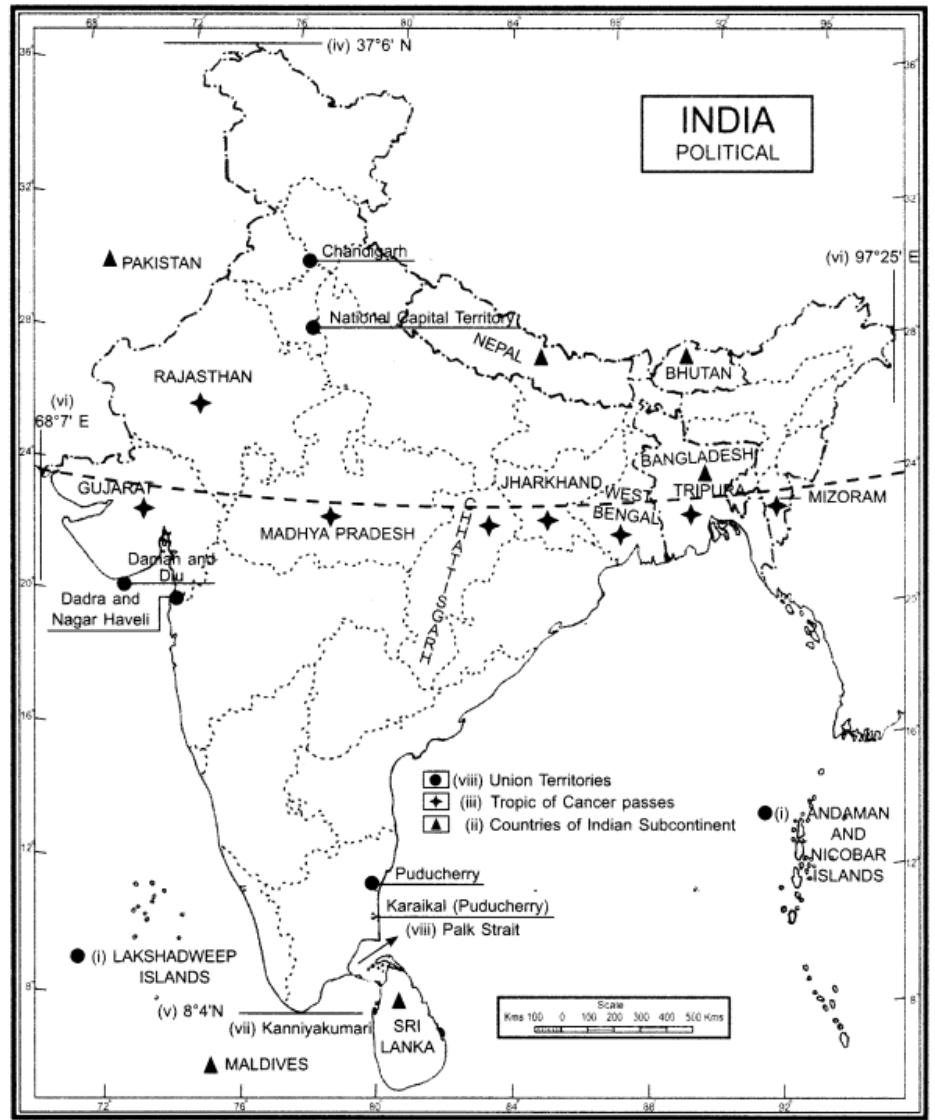
MAP SKILLS
Q1. Identify the following with the help of map reading.
(i) The island groups of India lying in the Arabian Sea and the Bay of Bengal.
(ii) The countries constituting Indian subcontinent.
(iii) The States through which the Tropic of Cancer passes.
(iv) The northernmost latitude in degrees.
(v) The southernmost latitude of the Indian mainland in degrees.
(vi) The eastern and the western-most longitude in degrees.
(vii) The place situated on the three seas.
(viii) The strait separating Sri Lanka from India.
(ix) The Union Territories of India.
Ans.
PROJECT/ACTIVITY
(i) Find out the longitudinal and latitudinal extent of your state.
Ans. As I belong to Haryana. Haryana extends from 27°39′ north to 30°55′ north latitudes and 74°28′ east to 77°36′ east longitudes
(ii) Collect information about the ‘Silk Route’. Also find out the new developments, which are improving communication routes in the regions of high altitude.
Ans. Silk Road, also called Silk Route, ancient trade route, linking China with the West, that carried goods and ideas between the two great civilizations of Rome and China. Silk went westward, and wools, gold, and silver went east.
The new developments which are improving communication routes in the regions of high altitudes are as follow :
1 Construction of motorable road by cutting rocks.
- Construction of bridges, tunnels, caves and railway line to connect different routes.
Development of telephone, satellite, phones and mobile phones improved the communication.