Class 9 Geography Physical Features of India Question Answer NCERT Solution in Hindi. NCERT Class 9 Geography Question Answer and Important Question Answer, Textual Question answer also Available for Various Board Students like HBSE, CBSE, UP board, Mp Board, RBSE and some other State Boards.
- Also Read:- Class 9 Geography NCERT Solution
- Also Read :- HBSE Class 9 All Subject Important Questions ( Latest )
- Also Read :- CBSE Class 9 All Subject Important Questions ( Latest )
NCERT Solution for Class 9 Geography Chapter 2 Physical Features of India textual Question Answer.
Physical Features of India Class 9 Geography Question Answer
Q1. Choose the right answer from the four alternatives given below.
(i) A landmass bounded by sea on three sides is referred to as
(a) Coast
(b) Island
(c) Peninsula
(d) None of the above
Ans. (c) Peninsula
(ii) Mountain ranges in the eastern part of India forming its boundary with Myanmar are collectively called
(a) Himachal
(b) Uttarakhand
(c) Purvachal
(d) None of the above
Ans. (c) Purvachal
(iii) The western coastal strip, south of Goa is referred to as
(a) Coromandel
(b) Konkan
(c) Kannad
(d) Northern Circar
Ans. (c) Kannad
(iv) The highest peak in the Eastern Ghats is
(a) Anai Mudi
(b) Kanchenjunga
(c) Mahendragiri
(d) Khasi
Ans. (c) Mahendragiri
Q2. Answer the following questions briefly.
(i) What is the bhabar?
Ans. The rivers, after descending from the mountains deposit pebbles in a narrow belt of about 8 to 16 km in width lying parallel to the slopes of the Shiwaliks. It is known as bhabar.
(ii) Name the three major divisions of the Himalayas from north to south.
Ans. Three major divisions of the Himalayas from north to south are as :
1 Great Himalayas or Himadri
2. Himachal or lesser Himalaya
3. Shiwaliks
(iii) Which plateau lies between the Aravali and the Vindhyan ranges?
Ans. The Malwa plateau lies between the Aravali and the Vindhyan ranges.
(iv) Name the island group of India having coral origin.
Ans. Lakshdweep island of India having coral origin.
Q3. Distinguish between
(i) Bhangar and Khadar
Ans.
| Bhangar | Khandar |
| 1. The largest part of northern plain formed of older alluvium lies above the floodplains of the rivers is known as bhangar. | 1. The newer, younger deposits of flood plains are called Khadar. |
| 2. The soil in this region contains calcareous deposite (kankar). | 2. They are very fertile because they renewed every year. |
(ii) Western Ghats and Eastern Ghats
Ans.
| Western Ghats | Eastern Ghats |
| 1. Average elevation → 900-1600 m | 1. Average elevation – 600 m |
| 2. Highest peak – Anai Mudi (2,695m) | 2. Highest peak – Mahendragiri (1,501m) |
| 3. They are continuous and can be crossed by passes only like Thal, Bhor and Pal Ghats. | 3. They are discontinuous and irregular and dissected by rivers fall into bay of bengal.
|
Q4. Which are the major physiographic divisions of India? Contrast the relief of the Himalayan region with that of the Peninsular plateau.
Ans. Major physiographic divisions of India are as :
(1) The Himalayan Mountains
(2) The Northern Plains
(3) The Peninsular Plateau
(4) The Indian Desert
(5) The Coastal Plains
(6) The Islands
| The Himalayan Region | The Peninsular Plateau |
| 1. It was formed due to the collision of the Indo-Australian and Eurasian plates. | 1. It was formed due to the breaking and drifting of the Gondwana land |
| 2. Mountain system of Himalaya represents a very youthful topography with high peaks, deep valleys, and fast-flowing rivers | 2. Peninsular plateau is composed of igneous and metamorphic rocks with gently rising hills |
| 3. It is a young fold mountain. | 3. It is oldest landmass of Gondwana land. |
Q5. Give an account of the Northern Plains of India.
Ans. The northern plain has been formed by the interplay of the three major river systems, namely — the Indus, the Ganga and the Brahmaputra along with their tributaries. This plain is formed of alluvial soil. The Plain covers 7 lakh sq km area and is also densely populated due to agriculturally productive climate conditions. Due to variations in relief features, the Northern plains can be divided into four regions – Bhabar, Terai, Bhangar and Khadar.
Q6. Write short notes on the following.
(i) The Indian Desert
Ans. The Indian desert lies towards the western margins of the Aravalli Hills. It is an undulating sandy plain covered with sand dunes receives very low rainfall below 150 mm per year. It has arid climate with low vegetation cover. Luni is the only large river in this region.
(ii) The Central Highlands
Ans. The part of the Peninsular plateau lying to the north of the Narmada river, covering a major area of the Malwa plateau, is known as the Central Highlands. The Central Highlands are wider in the west but narrower in the east.
(iii) The Island groups of India
Ans. There are two island groups of India are as :
1. Lakshadweep Islands :- This group of islands consists of small coral islands. This island group has great diversity of flora and fauna.
2. Andman and Nicobar Islands :- This group of islands is situated in Bay of Bengal. This island is also reach in flora and fauna.
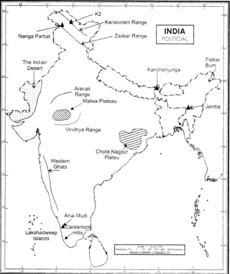
MAP SKILLS
On an outline map of India show the following.
(i) Mountain and hill ranges – the Karakoram, the Zaskar, the Patkai Bum, the Jaintia, the Vindhya range, the Aravali, and the Cardamom hills.
(ii) Peaks – K2, Kanchenjunga, Nanga Parbat and the Anai Mudi.
(iii) Plateaus, Chotanagpur and Malwa
(iv) The Indian Desert, Western Ghats, Lakshadweep Islands
Ans.